Positioning
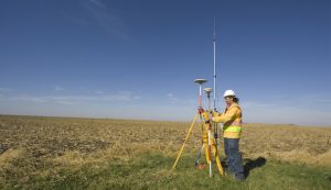 Originally GNSS were developed to provide a user position. The accuracy was at the level of tens of meters. In recent years, GNSS technology has been being developed considerably, taking into account global constellations as well as user receivers,. Currently, a sub-millimeter accuracy of static positioning can be achieved in post-processing mode and kinematic positioning with few centimeters of accuracy in real-time. Moreover, more GNSS applications were developed e.g. remote sensing of the troposphere and ionosphere, or time transfer. Although GNSS have a great potential in many scientific areas, positioning still remains the leading area of interest, with more than 4 billion of GNSS receivers worldwide (GSA, 2016). One of the substantial fields of GNSS positioning application is early warning systems that are able to detect earthquakes and their unavoidable consequences – tsunami waves (Collins et al., 2009, Li et al., 2013).
Collins P, Henton J, Mireault Y, Heroux P, Schmidt M, Dragert H, Bisnath S (2009). Precise point positioning for real-time determination of co-seismic crustal motion. In Proceedings of ION/GNSS pp 2479-2488.
European Global Navigation Satellite Systems Agency (GSA), 2016: GNSS user technology report.
Li X, Ge M, Zhang X, Zhang Y, Guo B, Wang R, Klotz J, Wickert, J. (2013) Realtime highrate coseismic displacement from ambiguity fixed precise point positioning: Application to earthquake early warning. Geophys Res Lett 40(2):295-300. doi:10.1002/grl.50138
Li X, Ge M, Zhang Y, Wang R, Xu P, Wickert J, Schuh H (2013) New approach for earthquake/tsunami monitoring using dense GPS networks. Sci rep 3:2682. doi:10.1038/srep02682