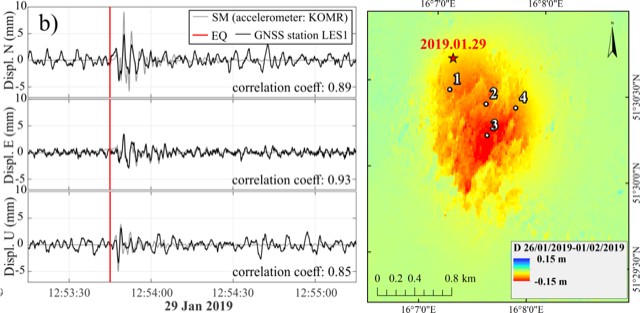
Most of us are used to thinking of earthquakes as devastating natural phenomena, but anthropological activities also can be responsible for some very serious earth shakes. One example of such an event relates to underground mining activity. Our study is focused on an event happened in Western Poland around Rudna Mine on 29 January, 2019. A collapse in the mine provoked an earthquake with Magnitude of 4.6. In order to estimate the severity and impact of the shock, we used several different sources of data – seismological and geodetic, and different data-processing strategies. From data recorded by a regional seismological network we estimated the source mechanism of the shock, which explains the parameters of the collapse that provoked the spread of the seismic waves in the ground surface. We used the records from a local seismological network to determine ground response in the short time after the moment of the collapse – peak ground acceleration, velocity and displacement (8mm horizontally and 1.5mm vertically). At a station for precise positioning (GNSS) located near to the epicenter of the shock (at Komorniki village) we detected changes in the position (coordinates) of this station for a short period of the shock. The result we interpreted as an alternative seismograph. We also revised a longer period of coordinate records for this station to validate the stable position of this point before and after the collapse. The other geodetic method that we applied in our study is based on satellite radar measurements (InSAR). They cover a period three months before and three months after the collapse and show the slow sinking (about 20cm/year before the shock and up to 50cm/year after the shock) due to the mining works in the range of the mine. For the time of the collapse these data revealed that the event affected an area of 2 square km and led to a subsidence of about 15 cm within six days.
Details of our study are presented in the paper “Combined Study of a Significant Mine Collapse Based on Seismological and Geodetic Data—29 January 2019, Rudna Mine, Poland” by Maya Ilieva1, Łukasz Rudziński2, Kamila Pawłuszek-Filipiak1, Grzegorz Lizurek2, Iwona Kudłacik1, Damian Tondaś1 and Dorota Olszewska2
Published in Remote Sensing (Special Issue Remote Sensing in Applied Geophysics) 2020, 12(10), 1570; https://doi.org/10.3390/rs12101570
1 Institute of Geodesy and Geoinformatics, Wrocław University of Environmental Life and Sciences
2 Institute of Geophysics, Polish Academy of Sciences
Funding: This study was conducted under the umbrella of the EPOS-PL project, POIR.04.02.00-14-A003/16,funded by the Operational Program Smart Growth 2014–2020, Priority IV: Increasing research potential, Action 4.2:Development of modern research infrastructure in the science sector. It was co-financed by the European Regional Development Fund. GNSS station LES1 was established as part of the EPOS-PL scientific geodetic infrastructure. This work was also partially financed by the Polish Ministry of Science and Higher Education in Poland as a part of its statutory activity No 3841/E-41/S/2020